


![]()
![]()
![]()
![]()
![]()
![]()
![]()
![]()
![]()


Archaeological Geophysics
|
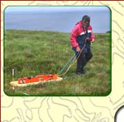
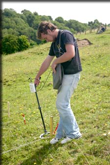 Field Magnetic Susceptibility Meter (Photo: Conor Brady) |
Magnetic susceptibility is an electromagnetic technique which assesses the ability of the topsoil or ploughsoil and features within it to be magnetised. This ability is largely related to the existence of certain mineral types which can be magnetised. Mineral types and their abundance are controlled by a combination of bedrock geology, glacial history and ancient and modern landuse. Burnt debris and also the incorporation of settlement and industrial waste in soils can enhance their magnetic susceptibility value. The technique is used in archaeological investigations to detect :
|
The technique can be used for field measurements, shallow borehole measurements and on soil and rock samples in the laboratory. In field surveys the depth of investigation can be from 0.1 to 1m depending on the nature of the site or area and former and current landuse e.g. deeply ploughed soils can provide results from deeper levels.
Field magnetic susceptibility surveys at an appropriate sampling scale can be used in the reconnaissance assessment of large sites. The interpreted data are then used to design a detailed geophysical survey strategy for areas or zones of enhanced magnetic susceptibility. The technique is often used to complement detailed magnetic gradiometry surveys where it is also used to define target areas and assist in the interpretation of the survey results. In detailed archaeological surveys and excavations field and laboratory magnetic susceptibility measurements can be used to map individual features or contexts and to select soil samples for further environmental analysis. |
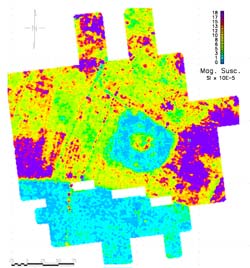 Magnetic susceptibility survey results showing in purple, zones of enhancement surrounding Rathcroghan Mound. (After Waddell et al., 2009) |
Laboratory Magnetic Susceptibility Measurements
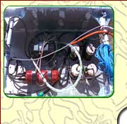
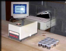 Laboratory Magnetic Susceptibility Measurements (Photo: Kevin Barton) |
Laboratory measurements can be used in a prospection strategy to assess possible archaeological activity or enhancement within the topsoil in advance of detailed field surveys or as a complement to them. Samples can also be taken from different contexts during excavation and may aid in identifying zones, layers or soils with increased archaeological activity. These enhanced soils can then be subject to further environmental analysis |
Archaeological Geophysics
Techniques
| Airborne LiDAR
| Magnetic Susceptibility
| Magnetic Gradiometry
| Earth Resistance
| Electrical Resistivity Tomography (ERT)
| Ground Penetrating Radar (GPR)
| Metal Detection
| Electromagnetic Methods |
Contact DetailsLandscape and Geophysical Services |
|